What is ARGO
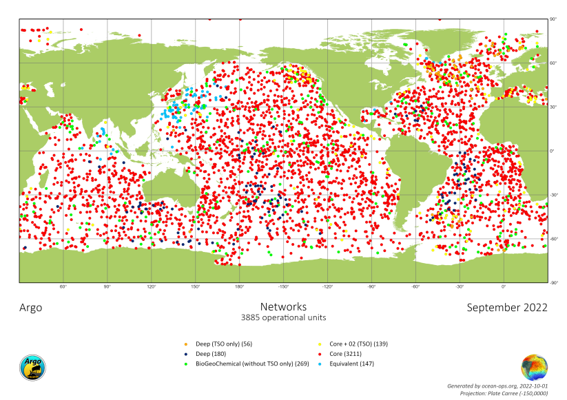
Argo is an international program that collects information from inside the ocean using a fleet of robotic instruments (called Argo floats) that drift with the ocean currents and move up and down between the surface and a mid-water level. At present Argo is collecting more than 12,000 data profiles each month (400 a day). This greatly exceeds the amount of data that can be collected from below the ocean surface by any other method. Argo plans to continue its data collection for as long as those data remain a vital tool for a wide range of ocean applications of which understanding and predicting climate change is but one.
How ARGO is organized and funded
There is no central funding for Argo. The Argo array is made up of 30 different countries’ contributions that range from a single float up to 50% of the global array. Each of the 30 countries that operate floats obtains their own national funding to buy floats, prepare and launch them and to process and distribute the data. Several other countries have assisted greatly with float deployments using everything from small research vessels to huge container ships. The Argo Program is managed by teams of scientists and data experts who ensure that the program is run as efficiently and effectively as possible and that standards are maintained at the highest possible level. Argo is part of the Global Ocean and Global Climate Observing Systems.
ARGO program contributing countries
| Argentina | Australia | Brazil | Bulgaria | Canada |
| Chile | China | Costa Rica | Denmark | Ecuador |
| European Union | Finland | France | Gabon | Germany |
| Greece | India | Ireland | Italy | Japan |
| Kenya | Korea | Lebanon | Mauritius | Mexico |
| Netherlands | New Zealand | Norway | Poland | South Africa |
| Spain | Turkey | UK | USA |
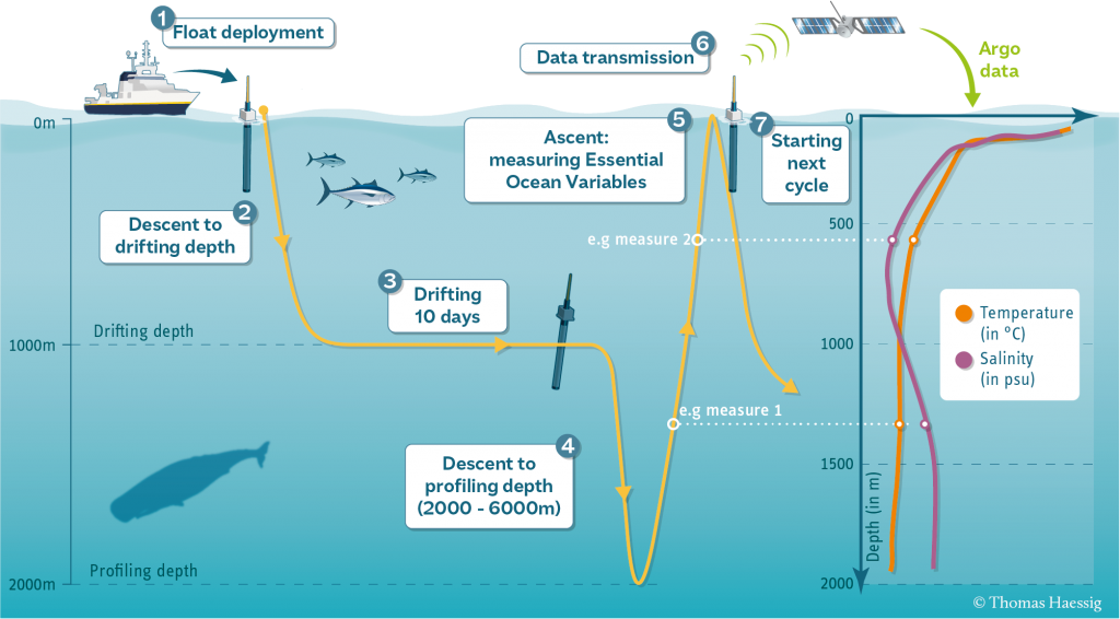
How do floats work
Data management
The international Argo Data System is based on two Global Data Assembly Centres, a series of 11 national Data Assembly Centres and several Argo Regional Centres. The float measurements are sent to regional data centres where they are given rigorous quality checks and then passed to two global data centres from where they can be accessed by anyone wishing to use them. GDACs (Global Data Centres), located at Coriolis/France and FNMOC/USA, are in charge of collecting the processed Argo data from the 11 DACs and to provide users with access to the best version of an Argo profile. Data are available, in a standard NetCDF format both on FTP and WWW. The two GDACs synchronize their database every day. ARCs (Argo Regional Centres) provide wide expertise on specific geographical ocean regions in order to provide the most comprehensive data sets (including non-Argo data) of the highest quality.
Some users have applications that require rapid access and so Argo aims for most “real-time” data to be available within 12 hours. Other applications need a higher-quality version that replaces the real-time data after lengthy comparisons between nearby floats and between float data and information from research ships.
A fundamental rule for Argo is that all data are freely and openly available.
Every effort is made to deliver data with the shortest delays possible and with extensive quality control. Hence there are real-time (less than 24 hours) and delayed mode delivery systems. The quality control procedures are the highest and most stringent for the delayed-mode data stream which is designed to deliver data for climate quality.
Where to find Argo data:
https://fleetmonitoring.euro-argo.eu/dashboard
http://www.coriolis.eu.org/Observing-the-Ocean/ARGO
https://www.ocean-ops.org/board
New missions:
- Biogeochemical Argo – Measuring biogeochemical parameters: oxygen sensors, pH, nitrate, chlorophyll-a, backscattering and irradiance sensors
- Deep Argo – Going to the ocean floor (6000 m)
Towards spatial completeness:
- Polar Argo – Argo under the ice
- Argo in Marginal Seas – Argo in the shelf zones


